lo
31°C, New York


Notification products, updates
NOAA Halts Storm Satellite Data Implications and Challenges
The National Oceanic and Atmospheric Administration (NOAA), a key agency responsible for monitoring weather and environmental conditions in the United States, recently made the unexpected decision to halt the release of certain storm satellite data. This move has raised concerns among meteorologists, emergency management officials, and the public, as timely satellite information is critical for forecasting storms, tracking hurricanes, and issuing life saving warnings.
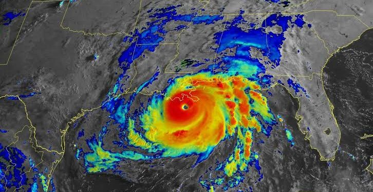
NOAA’s satellite program provides continuous real time data about the atmosphere, ocean, and land surface, which helps forecasters analyze storm development and movement. Satellite imagery and sensor data enable weather models to predict the intensity and trajectory of hurricanes, tropical storms, and other severe weather events. When this data stream is interrupted or delayed, the accuracy of forecasts can suffer, potentially leaving communities less prepared for natural disasters.
The suspension was reportedly linked to ongoing technical upgrades and system maintenance designed to improve data quality and processing capabilities. While such updates are necessary for long term enhancements, the immediate consequence has been a temporary gap in data availability. NOAA officials have reassured the public that alternative data sources and backup systems are in place to minimize disruption, but experts warn that these substitutes may not fully replace the precision and detail provided by the main storm monitoring satellites.
This pause in data release comes at a particularly sensitive time, as the Atlantic hurricane season enters its peak months. Forecasters rely heavily on satellite observations to detect early signs of storm formation, monitor changes in storm structure, and predict landfall locations. Without timely satellite updates, there is a risk that forecast lead times may shorten, affecting evacuation planning and resource mobilization efforts.
The issue also highlights broader challenges faced by NOAA and similar agencies globally, including funding constraints, aging satellite infrastructure, and the complexity of integrating new technologies. Modern weather satellites operate with sophisticated instruments that require continual calibration and software updates. Balancing maintenance needs with uninterrupted data provision remains a delicate and ongoing challenge.
In response, NOAA has emphasized its commitment to restoring full data services as quickly as possible. The agency is working to accelerate the upgrade process while maintaining the reliability of weather forecasts. Additionally, collaboration with international partners, such as the European Space Agency and Japan Meteorological Agency, provides supplementary satellite data that can help fill temporary gaps.
Looking ahead, this event underscores the vital importance of investing in resilient satellite systems and diversifying data sources. As climate change leads to more frequent and intense storms worldwide, the demand for accurate and timely weather information will only grow. Agencies like NOAA must prioritize not just technological upgrades, but also robust contingency planning to ensure continuous support for communities vulnerable to extreme weather.
In summary, NOAA’s temporary halt in storm satellite data availability reflects the complexities of maintaining critical observational systems amid necessary upgrades. While the pause poses short term challenges, it also serves as a call to strengthen and modernize global weather monitoring infrastructure ensuring that, even during transitions, society remains equipped to predict and respond effectively to the storms ahead.