lo
31°C, New York


Notification products, updates
Tropical Depression Forms Over Southeast U.S., Bringing Torrential Rain and Flash Flood Threats
1. Weather System Gains Strength Over Land
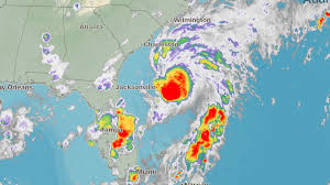
A tropical depression has formed over the Southeastern United States, bringing heavy rainfall, gusty winds, and heightened flood risks to several states including Georgia, South Carolina, Alabama, and parts of Florida. Though the system originated from a disorganized mass of thunderstorms over the Gulf of Mexico, it began to consolidate as it moved inland. Now classified as a tropical depression by the National Hurricane Center (NHC), the slow moving system is producing widespread precipitation and localized severe weather conditions, particularly in coastal and low lying areas.
Meteorologists emphasize that even without hurricane strength winds or coastal storm surges, tropical depressions can be extremely dangerous, especially when they stall or move slowly across saturated terrain. The current depression is projected to hover over the region for up to 48 72 hours, dumping between 4 to 8 inches of rain, with some areas potentially seeing more than 10 inches depending on localized storm bands.
2. Flash Flood Warnings and Evacuations
The National Weather Service has issued flash flood watches and warnings for large portions of the Southeast. Areas most at risk include Savannah (GA), Charleston (SC), Tallahassee (FL), and Birmingham (AL), where already saturated grounds could quickly become overwhelmed. Emergency response teams in multiple counties have activated flood response protocols, and voluntary evacuations have been ordered in parts of South Carolina’s coastal flood zones.
Local authorities have also warned of urban flooding, particularly in downtown areas with poor drainage systems. In addition, rivers like the Ocmulgee in Georgia and the Black Warrior in Alabama are being closely monitored for rising water levels. Emergency shelters have been opened in flood prone counties, and residents are being urged to avoid travel unless necessary.
3. Wind Gusts and Tornado Threats
Though the tropical depression lacks hurricane force winds, it is still producing gusts between 35 45 mph, enough to knock down tree limbs, cause minor structural damage, and down power lines. Thousands of homes across Georgia and the Florida Panhandle briefly lost power as winds intensified overnight. Utility crews are working to restore services but warn that conditions may hamper repairs if the depression lingers longer than expected.
The system has also triggered severe weather alerts, including isolated tornado watches, particularly in southeastern Georgia and northern Florida. Atmospheric instability, combined with high humidity and upper level shear, has created conditions ripe for brief tornado spin ups, especially in the outer bands of the depression.
4. Agricultural and Economic Concerns
The tropical depression is also raising concerns for agricultural operations, particularly in the heart of the Southeast’s peach, peanut, and cotton regions. Flooded fields and persistent cloud cover are expected to negatively impact crop yields, with some local growers already reporting damage to root systems and early season harvests. In coastal fishing communities, small craft advisories have been posted, grounding local fleets and halting operations in estuaries and nearshore waters.
Economic losses may mount quickly if flooding spreads into commercial centers or transportation corridors. The I 95 and I 75 corridors, critical to shipping and travel along the East Coast, are being monitored for closures or restrictions as rainfall accumulates.
5. Forecast and Movement Path
As of the latest update, the tropical depression is expected to slowly move northeastward toward the Carolinas and Virginia over the next two days. While the system is not expected to regain strength to tropical storm status due to lack of warm water fuel, it could still deliver damaging rains and localized wind events far inland. Forecast models show the system exiting into the Atlantic by the weekend, potentially reforming into a subtropical system off the East Coast.
The NHC and NOAA are closely tracking its progression, issuing real time updates to weather services and local governments. Residents are advised to monitor official alerts, prepare emergency kits, and stay indoors during periods of heavy rainfall or high wind.
6. Public Response and Preparedness
Local governments across the Southeast are taking no chances, recalling past events like Tropical Depression Claudette (2021) and Alberto (2018), both of which caused major flooding and fatalities despite lacking hurricane status. Public schools in some counties have preemptively closed, and emergency hotlines have been activated. Public works departments are deploying sandbags, clearing drainage ditches, and preparing for potential water rescues.
The Federal Emergency Management Agency (FEMA) has placed response teams on standby in case the storm's impact intensifies or expands. In flood prone neighborhoods, residents are urged to elevate electronics, safeguard important documents, and heed local evacuation advice without delay.
7. A Stark Reminder of Non Hurricane Risks
This developing situation is a stark reminder that not all dangerous storms come with hurricane names or high category warnings. Tropical depressions may not grab headlines like hurricanes, but they carry the power to disrupt lives, cause deadly flash floods, and create long lasting damage. Experts continue to highlight the need for better public awareness around the hidden dangers of slow moving tropical systems, especially in a warming climate where storms are behaving more unpredictably.
As the system continues to drift across the Southeast, forecasters, emergency personnel, and citizens alike remain on high alert, navigating a familiar threat made more intense by a changing climate and vulnerable infrastructure.
Let me know if you need a visual weather map, state by state breakdown, or timeline of the storm’s movement.